The LIMMMA Platform
Introduction
The University of Sussex LIMMMA platform is designed to contribute to the timely and effective use of evidence for collaborative sustainable multifunctional land use initiatives in diverse contexts around the globe. Our central aims in developing this platform are to complement the growing number of decision support tools and landscape modelling approaches by:
- supporting the rapid sharing, analysis and comparison of new data and model developments that have implications for sustainable land use policy and land management practices;
- supporting efforts to scale up and extrapolate from new empirical findings as appropriate;
- supporting engagement with the uncertainties involved and comparisons with existing data sets and model outputs to inform bespoke decision making;
- enabling specialists and non-specialists to engage more quickly and easily with the evidence, assumptions and uncertainties involved in developing, selecting and monitoring land management options.
Current applications of LIMMMA
Examples of interest groups and potential uses of LIMMMA for nature recovery include (but are not limited to):
1. Scientific Research Teams carrying out empirical studies to improve understanding of landscape function
Many scientific teams are doing field-based research and biophysical modelling to understand the relationships between the changing function and value of landscapes and management practices to meet net zero, biodiversity targets and other sustainability goals. LIMMMA provides a platform to:
- visualise, analyse and share findings as they emerge;
- run models derived from empirical findings across different scales (for example factors influencing carbon storage for particular habitats);
- compare outputs of new models against established ones currently used in land-use decision making;
- explore uncertainty in datasets and models;
- support dialogue at the science policy interface.
Large scale multi-site research projects such as the Nature Returns programme work at multiple pilot sites, seeking to understand how nature based solution interventions can restore and create habitats to obtain multiple benefits for nature and people at the landscape scale. For this type of initiative LIMMMA can help with sharing the data across sites and learning together rapidly with multi-site visualisation and analysis. It provides a way to integrate diverse types of geospatial data into models and maps for complex analysis while also making outputs and evidence accessible to other expert and non-expert stakeholders alike.
LIMMMA enables the possibility of using a single model and consistent data sources at very high resolution for local areas (e.g. 0.5 - 3m resolution aerial and satellite imagery), and simultaneously at regional or national levels making it easier to model the potential impact of land use decisions across different scales (see the carbon report download) and to explore the limits to scaling of particular models.
2. Practitioners
Practitioners such as the Local Nature Recovery Strategy (LNRS) teams are designing landscape wide strategies for nature recovery projects in consultation with communities. They need opportunity maps that can be readily improved with input from local stakeholders and which provide transparency over candidate site selection. LIMMMA has the potential to help by:
- bringing together multiple datasets, models and maps from other planning and policy units into a single platform;
- allowing “real-time” updates to maps as new evidence and models emerge;
- enabling maps to be augmented with other local monitoring datasets and stakeholder inputs for context-appropriate planning;
- supporting participatory monitoring and feedback of nature recovery interventions;
- looking at synergies and trade-offs across scales and between land-use priorities - for example local site-level assessments and plans can be understood in the wider context of housing and food security priorities.
3. Communities
It is well recognised that successful nature recovery initiatives rely on effective collaboration and knowledge sharing between local communities (residence, farmers, advocacy groups etc), scientists and others. Building on experience from our earlier community focused work (ESPA, Inclusive Green Infrastructures) and through our new collaboration with Monash University Indonesia we are keen to develop the capabilities of LIMMMA to support citizen science and the gathering of local evidence on landscape function and value to create bespoke maps. These could be applied within planning processes to convey local communities’ experience of and vision for nature recovery and NBS projects in their localities. This democratisation of landscape planning (which recognises the diversity of biophysical and socio-cultural landscape values) is central to strong community engagement and achieving realistic and lasting interventions.
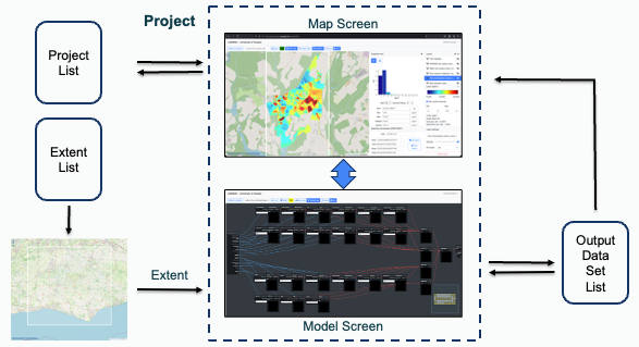
The LIMMMA Platform
In the simplest technical terms, LIMMMA is a web-application with mapping and modelling functions and a growing set of built-in datasets which can be augmented with additional data layers generated or owned by users themselves. The majority of the open datasets currently built-in to LIMMMA cover the United Kingdom but there is scope to use LIMMMA with local and national datasets and map layers from anywhere in the world. The platform itself consists of a project menu, map screen and model screen through which the user can interact with projects on specific geographical areas (extents) to generate outputs in the form of maps and datasets.
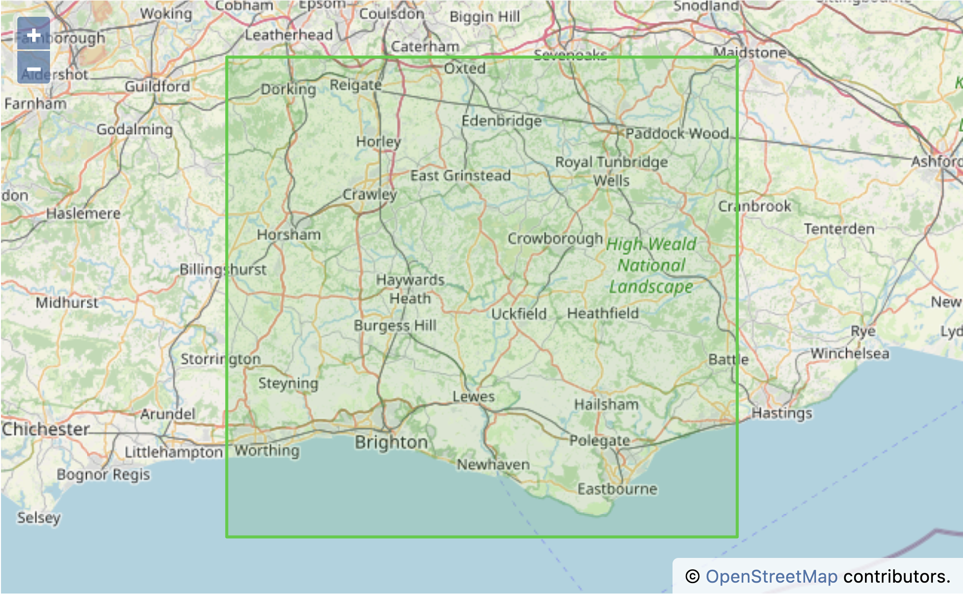
One key aspect of our overall vision is to develop the LIMMMA platform into a ‘virtual living lab for multifunctional landscapes’ that would provide a basis for bringing formal science and other insights together as a common resource. It would enable a coalition of research and practitioner teams to progressively build up an understanding and visualisation of the changing function and values of landscapes. It could provide a platform for participatory assessment of the implications of different land use interventions, integrated with dynamic maps that are updated with new evidence and stories of change. By facilitating engagement between scientists, practitioners, communities and policy makers, such a virtual living lab would support a more responsive and participatory strategy for multifunctional landscapes. Towards this goal, we are beginning to work with stakeholders to scope this initiative out within a specific area in the south coast region (see map below).
This book of documentation introduces the LIMMMA platform, outlines its key features and explains how it can be used in a number of example use-cases with a step-by-step walkthrough for each case. Chapter 1 outlines the key features while Chapter 2 takes the reader from zero to the basics of how to set up an account, create a new project and add map layers. Chapters 3, 4 and 5 (forthcoming) detail three specific use cases to demonstrate how the platform can be used in each case. Finally, chapter 6 (forthcoming) gets into the more technical detail about how the AI component is used to support land use classifications.
If you want to know more about the history and development of the project before going further you can read about it in the section below. Otherwise, if you want to learn about the platform itself, please head straight to Chapter 1.
Background and acknowledgements
(placeholder): add in details of our long-term interdisciplinary research on multifunctional landscape initiatives and challenges of integrating evidence and perspectives across scales, multiple perspectives and diverse values.
The University of Sussex LIMMMA platform (Landscape Integrative Mapping and Modelling for Multifunctional Analysis) is an evolving project that began in 2017 with a new multi-disciplinary collaboration between the University’s Science Policy Research Unit (SPRU) and the Predictive Analytics Lab (PAL) within the Informatics department.
This initial proof of concept stage of development was funded by the University of Sussex’s SSRP initiative (Sussex Sustainability Research Programme). Just as machine learning and AI was beginning to be applied more widely to computer vision problems such as object detection and image segmentation this project brought together a core team of researchers to develop a web-application to enable AI-assisted land cover and land use classification for geospatial analysis. By collaborating across the traditional separation between social science and engineering we were able create a bespoke platform for non-expert users to generate and analyse LULC (land use land cover) maps from satellite imagery in peri-urban contexts where conventional methods of land cover classification break down due to the complexity of the landscape.
The British Academy funded our team to continue development of the platform as part of an interdisciplinary research project titled “Inclusive Green Infrastructures for Urban Wellbeing” under the British Academy Urban Infrastructures of Well-being Programme. During this phase of development, a prototype modelling system was built into the platform to enable the analysis of land use changes over time and to implement a scoring system to visualise the impacts of those changes on different stakeholders.
Subsequently, our team joined a large consortium project to apply and further develop the LIMMMA platform to support decision and policy making around nature recovery, nature based solutions and multifunctional landscape strategies. This is a programme called Nature Returns funded by the Joint Treasury Outcome Fund and led by Natural England. The Sussex team co-Is (working directly with Kew Science) are Fiona Marshall, Novi Quadrianto, Jeremy Reffin and team members include Izabela Delabre, Paul Crossley, Leonidas Gee and Jonathan Dolley.
During this project we completely rebuilt the LIMMMA platform to enhance and fully integrate the mapping, modelling and AI elements. Alongside this we worked with scientists at Kew to use LIMMMA to support their emerging work on landscape-based carbon and biodiversity monitoring and modelling. The culmination of this work is the LIMMMA platform presented in this documentation. However, it is not simply a finished piece of software but is part of an ongoing transdisciplinary research effort to support creative engagement over landscape management strategies between multiple stakeholders from policy makers to local communities and scientific researchers. As such, we see LIMMMA as an evolving platform around which to gather these diverse stakeholders for engagement with emerging evidence and differing values and assumptions about how we want to improve our local and national landscapes.